
Maps of Halkidiki for Modern Travellers by Car or Without and a History of Maps of Kassandra, Sithonia, and Mount Athos
Halkidiki, also spelled Chalkidiki, is one of the most recognisable regions in northern Greece and also one of the most mapped. It lies southeast of Thessaloniki and extends into the Aegean Sea in three long peninsulas that almost look drawn by hand. Kassandra to the west, Sithonia in the centre, and Mount Athos to the east. Even people who have never visited Greece often recognise Halkidiki on a map because of this unusual shape.
For travellers, this shape is not only visual but practical. Distances look short on a map but can feel longer on the ground, especially when moving between peninsulas. Roads follow the coastline, forests, and hills, and sometimes a beach that looks close requires a long drive. Because of this, maps have always played an important role in how people understand and move through Halkidiki, from ancient sailors to modern visitors with smartphones.
Today Halkidiki attracts people travelling by car, bus, boat, and sometimes without any vehicle at all. Some stay mostly on Kassandra, others explore Sithonia slowly, and a few focus on the sea around Mount Athos.
To make sense of all this, travellers still rely on maps, even if those maps now live on screens instead of folded paper. At the same time, Halkidiki has a long and surprisingly rich cartographic history that reflects how the region was seen by outsiders over many centuries
Try our traveller activities!
2026 Map of Halkidiki featuring Kassandra Sithonia Mount Athos Thessaloniki and the airport
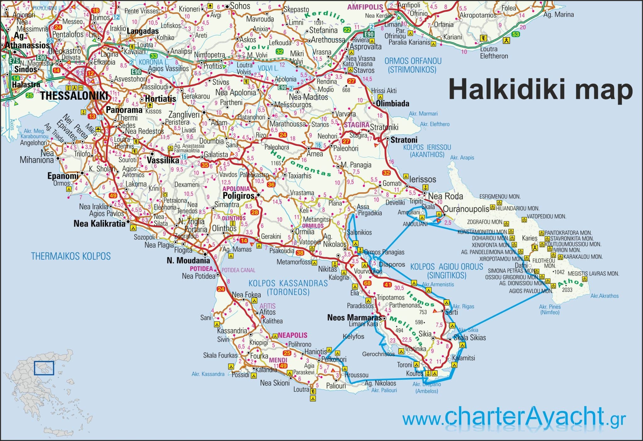
This kind of general map is often the first one visitors encounter. It shows the overall structure of Halkidiki, its connection to Thessaloniki, and the main access points such as the airport. For first time visitors, this helps build a mental image of where things actually are, which peninsula is closer, and how travel time might feel in reality, not just in kilometres.
Maps for Modern Travellers
Modern travellers have access to more maps than at any other point in history. Most visitors to Halkidiki now rely on digital maps, especially when driving. Google Maps is widely used and offers reliable road navigation, traffic conditions, and information about beaches, tavernas, fuel stations and small villages. In busy summer months this can be useful, although sometimes local knowledge still beats algorithms.
Bing Maps provides similar coverage and slightly different satellite imagery, which some people prefer when looking at terrain and coastline. OpenStreetMap is also widely used and in some parts of Halkidiki it can be surprisingly detailed. Small forest roads, hiking paths and minor coastal tracks are sometimes better represented there than on commercial platforms, especially in Sithonia where development is lighter.
Despite all this, paper maps have not disappeared. Many travellers still pick up printed maps from hotels, car rental offices or tourist information points. The Greek National Tourism Organisation and local publishers produce maps that highlight beaches, archaeological sites, monasteries and main roads. These maps are not always perfectly accurate but they give a good overview and do not depend on signal or battery life, which still matters in some remote areas.
2026 Map of Halkidiki with Kassandra and Sithonia
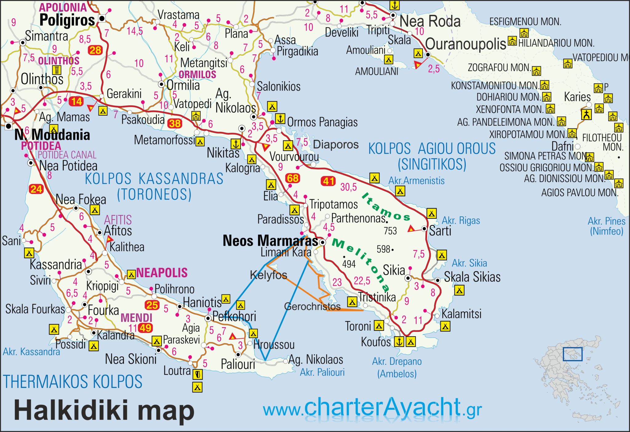
This type of map is especially useful for travellers who focus on the western and central peninsulas. Kassandra is more developed and easier to navigate, while Sithonia feels more spread out and wild. Seeing both together helps understand why travel between them often takes longer than expected, even though they sit side by side on the map.
Don’t forget to check out our summer 2026
Private Halkidiki day sailing boat 5 or 7 hours trips
or try our traveller activities!
Why Halkidiki Appears So Clearly on Maps
Halkidiki is one of those regions that mapmakers remember. Its shape makes it stand out immediately, even on small scale maps of Greece or the Balkans. The three peninsulas create natural reference points and this helped early cartographers, even when coastlines were poorly surveyed. A traveller looking at a map in the 17th century would already recognise that this was a place with three distinct extensions into the sea, even if the distances and angles were not quite right.
This visibility also explains why Halkidiki appears relatively often in historical maps compared to other Greek regions of similar size. Sailors moving through the northern Aegean needed to understand where these peninsulas lay, and land routes from Thessaloniki toward southern Greece passed close by. Maps did not just describe Halkidiki, they used it as a spatial anchor.
Ancient Names and How They Survived on Maps
Many old maps of Halkidiki use names that are no longer used in everyday language. Kassandra often appears as Pallene, Sithonia as Sithonia or Longos, and Mount Athos simply as Athos. These names came from ancient Greek geography and were copied again and again by European cartographers who relied on classical texts. Sometimes they were placed inaccurately, but the names themselves survived for centuries.
Stageira, the birthplace of Aristotle, is one of the most frequently marked ancient cities on maps of Halkidiki. Even when cartographers were unsure of exact locations, they felt compelled to include it because of its philosophical importance. This is why Stageira appears prominently on maps like the 1694 Sanson map, even though many smaller settlements are missing.
Ottoman Period Maps and Gaps in Knowledge
During the Ottoman period, Halkidiki continued to be mapped, but often indirectly. European cartographers rarely visited the region themselves. Instead, they relied on reports, older maps, and second hand descriptions. As a result, maps from the 17th and 18th centuries sometimes show excellent coastlines but very vague interiors, especially in Sithonia.
Mount Athos was an exception. Because of its monasteries and international connections, information about Athos circulated more widely. Maps often show the peninsula in detail while leaving neighbouring areas almost empty.
This contrast is visible even today when comparing different historical maps side by side.
Road Maps and the Rise of Tourism
Modern road maps of Halkidiki developed mainly after the Second World War. As tourism grew and infrastructure improved, new editions appeared regularly. These maps started to include beaches, camping sites, archaeological zones and later hotels. Kassandra was usually updated first, followed by Sithonia, while Mount Athos remained mostly schematic due to access restrictions.
Early tourist maps were sometimes optimistic. Roads appeared straighter than they were, and distances felt shorter on paper. Anyone who has driven through Sithonia knows how misleading that can be. Still, these maps played an important role in shaping how travellers imagined the region before arriving.
Digital Maps and Local Corrections
Even today, digital maps of Halkidiki are not perfect. Locals often notice small errors, missing turns or outdated business names. In summer, temporary beach access roads appear that never make it onto official maps.This is why many residents keep their own mental maps, shaped by years of movement rather than coordinates.
User edited maps, like custom Google Maps lists or OpenStreetMap contributions, help correct this slowly. Over time, footpaths, coves and minor roads get added. This ongoing process mirrors older cartographic traditions more than people realise, maps evolving through shared experience rather than central authority.
Halkidiki Maps for Walking and Hiking
Walking maps of Halkidiki are less common but increasingly important. Sithonia and parts of Mount Athos have long walking traditions, used by monks, shepherds and woodcutters. These paths rarely appeared on early maps.
Only recently have hiking routes begun to show up clearly on digital platforms and specialised paper maps. Some of the most reliable walking routes are still passed on by word of mouth. A map might show a line, but the ground tells a different story. In this sense, Halkidiki remains a place where maps and lived geography sometimes disagree slightly, and that is not always a bad thing.
Why Old Maps Still Matter
Looking at historical maps of Halkidiki is not just an academic exercise. They show how the region was imagined at different times. What was important, what was ignored, and what was misunderstood. Comparing old and new maps helps explain why certain areas developed faster than others, and why some places still feel remote. For travellers today, this adds another layer of understanding. Driving through a quiet inland village or sailing past an isolated stretch of coast feels different when you realise how long these places existed at the edges of maps, half known and rarely visited.
History of Maps of Kassandra Sithonia and Mount Athos
Long before modern travel maps, Halkidiki already existed in the geographical imagination of the ancient world. Ancient Greek authors such as Herodotus and Thucydides mentioned cities of the region, especially in connection with the Persian Wars. While original Greek maps rarely survive, later reconstructions suggest that the idea of three projecting landforms was already known, even if drawn in a very abstract way.
In Roman times, Halkidiki appeared in regional maps of Macedonia and the northern Aegean. These maps were often part of larger works that focused on roads, ports and military logistics. Accuracy was not the main goal. What mattered was relative position, strategic importance and connectivity. Mount Athos was noted as a prominent landmark for sailors, even before it became a monastic centre.
During the Byzantine period, mapping became more practical and administrative. Castles, monasteries and defensive points were more important than exact coastlines. Mount Athos gained increasing significance from the 9th century onward as monastic life expanded. From this time, the peninsula starts to appear more clearly named in texts and schematic maps, often labelled simply as “Athos”.
Early modern European cartography marked a turning point. From the 16th century onward, printed maps of Greece and the eastern Mediterranean began circulating widely. Cartographers such as Abraham Ortelius and Gerardus Mercator included Halkidiki in their atlases. They usually used classical names like Chalcidice and combined ancient sources with traveller reports. The shape of the three peninsulas became more recognisable, though still distorted by modern standards.
In the 17th century, French cartographer Nicolas Sanson produced influential maps of Macedonia that included Halkidiki. These maps often showed ancient cities such as Stageira alongside Ottoman era settlements. They reflect a scholarly attempt to reconcile classical geography with contemporary political realities, even if field surveys were limited. By the 19th century, cartography became increasingly scientific. French, Austrian and later Greek surveyors produced detailed topographic maps of Halkidiki. These maps recorded elevations, rivers, forests and coastlines with much greater precision. They were used not only for travel but also for administration, archaeology and military planning, especially during the period leading up to the incorporation of the region into the modern Greek state.
2026 Map of Kassandra Halkidiki Greece

Kassandra has always been easier to map than the other peninsulas. Its road network developed earlier and its coastline is more regular. Older maps often show it more accurately than Sithonia, which remained forested and sparsely populated for longer. For modern travellers, maps of Kassandra are usually straightforward and reliable, both digitally and on paper.
2026 Map of Sithonia Halkidiki Greece
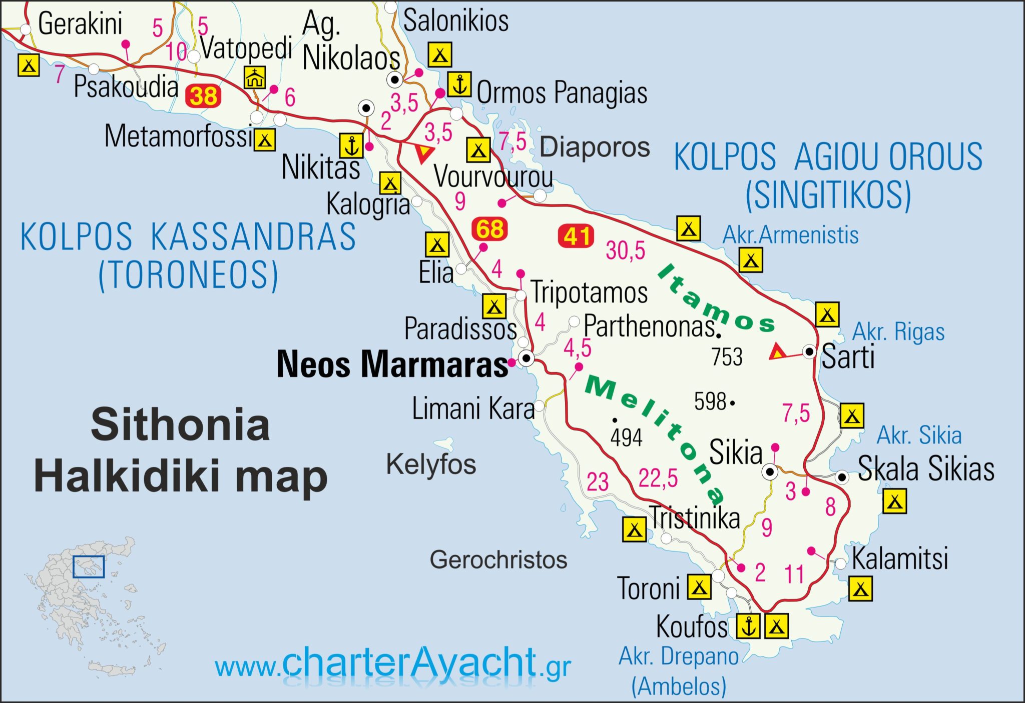
Sithonia is different. Its coastline is complex and its interior mountainous. Older maps often simplified it or left large areas blank. Even today, digital maps sometimes miss minor roads or paths. For travellers who like exploring, this is part of its appeal, but it also explains why good maps still matter here more than in other parts of Halkidiki.
2026 Map of Mount Athos Halkidiki Greece
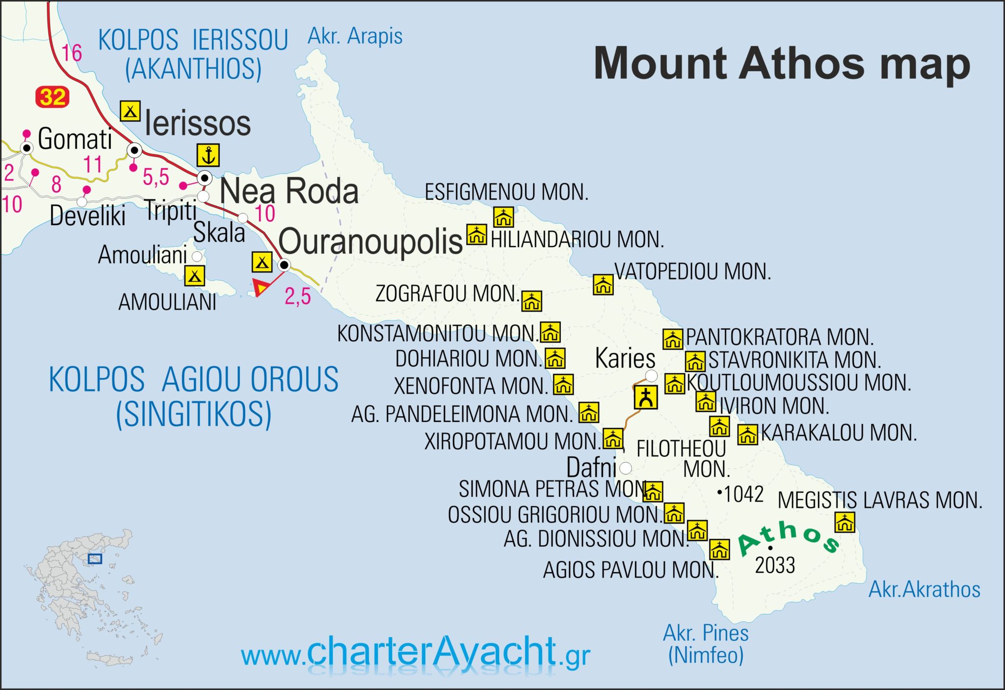
Mount Athos occupies a special place in the history of mapping. Because access is restricted, many maps rely on older sources or official outlines. Monasteries are often the main features shown, sometimes more prominently than natural geography. For sailors, however, the coastline of Athos has always been important, as it marks a long and exposed stretch of sea.
Sea Maps of Halkidiki for Boats and Sailors
Halkidiki is a popular sailing area, not only for tourists but also for local fishermen and transport. The waters around Kassandra and Sithonia are generally sheltered, while the eastern side of Mount Athos can be more demanding. Because of this, sea maps have always been essential for anyone navigating these waters
The Greek Hydrographic Office produces official nautical charts covering the entire coastline of Halkidiki. These charts show depths, seabed types, rocks and navigation aids. They exist in paper form and also as electronic charts used with modern plotters. Systems like Navionics and C-MAP are common among visiting yachts, although experienced sailors still consult paper charts and local advice.
Chalkidiki map Halkidiki mapa 2026
Check out this Halkidiki map with Google Maps. It reflects personal experience and favourite places rather than official classifications. These kinds of maps are often the most useful, because they grow over time and reflect how people actually move and stop in the region.
or click here to see this map at Google Maps
Chalkidiki historical maps

Detail of a map of Macedonia by Nicolas Sanson from 1694, showing the wider region including Chalkidiki and the location of ancient Stageira. Maps like this mix classical knowledge with early modern interpretation, and they show how the region was understood long before accurate surveys existed.
from the “My Favourite Planet – the online travel guide” www.my-favorite-planet.de
Click here for more historical maps of Chalkidiki and related history
Try our traveller activities!
call us: +306980700070
send a message via WhatsApp
call or text us on Viber
send a message via Messenger
Don’t forget to mention:
- Number of persons, possible dates
- The hotel you’ll be staying
- The activity you are interested in